blogdowntown
Not currently logged in. [Login or Create an Account]

Stay Connected


Regional Connector Down to Two Alternatives

By Eric Richardson
Published: Wednesday, May 07, 2008, at 05:41PM
2nd Street with Regional Connector Metro

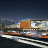
A rendering of 2nd street with above-ground operation of the Regional Connector.

Planning for the Regional Connector is down to two preferred alternatives, one above ground and one below. Costs for the two differ by only $150 million.

At a meeting of the Bringing Back Broadway Streetcar Committee this afternoon, Metro staff presented the Connector project, intended to link the Blue and Expo light rail lines with the two parts of the Gold Line. At peak times, 48 trains per hour will use the Connector.

The cost difference between the two was much narrower than many had expected. The above-ground Connector estimates came in at $650 million, with a subway alternative at $800 million.

Eight alternatives were presented at meetings in February, but only two will move forward in the Alternatives Analysis process.

The above-ground alternative -- Alternative 3B in Metro's original presentations -- would begin below-grade on Flower, connected to the existing tail tracks at the 7th / Metro station. It would come above ground at 4th, where it would have a surface station. It would cross 3rd street at-grade below cutting into the 2nd street tunnel and turning east. The Connector would turn north off of 2nd, using Main and Los Angeles streets in a paired-couplet configuration before turning right at Temple and connecting to the Gold Line above the Little Tokyo / Arts District station.

2nd street would be removed from normal auto service, and only a single access lane would be provided along the portion travelled by the Connector.

The below-ground alternative -- Alternative 5 from the original eight -- would run as a complete subway, heading north on Flower and turning east under 2nd. It would surface in the lot currently occupied by the Office Depot in Little Tokyo, and would cross Alameda at-grade. Stations would be located roughly at 5th & Flower, 2nd & Hope and 2nd & Spring / Main.

Metro hopes to complete its Alternatives Analysis within a year, and start the process of going after Federal New Start funds. Staff today said that the Connector project should score as one of the most competitive projects in the country.

Initial operation plans would have trains running north-south and east-west, with one line running Long Beach to Pasadena and the other from Culver City to East L.A.

SHARE:

||

Related Topics


Topic:
Regional Connector

35 stories


Conversation

Guest 1

Bert Green on May 07, 2008, at 06:29PM – #1

This is good news. I prefer the subway alignment, as do most others I know. And 800 million is on par with the other spurs, making it feasible to build.


Guest 2

David Kennedy on May 07, 2008, at 06:41PM – #2

I drive through Little Tokyo and 2nd Street pretty much every day taking my kids to daycare. My concerns are two-fold.

1) What will be the impact on Little Tokyo? Which route will have the least impact during construction? The above ground route will effectively kill the businesses on 2nd Street. 2nd Street has become one of the more lively streets in downtown. It would be a shame to kill it off. My fear is that the combination of construction and then closing it to car traffic would ultimately do that. That would be a shame.

2) What will be the impact of above rail traffic through the heart of the Civic Center? Spring, Main, Los Angeles and San Pedro are key north-south corridors. Hopefully, some good computer simulations can test out the long-term impact. I fear at-grade crossings along 2nd would impede traffic flow.

My gut tells me the underground alternative is the better option for these two reasons. I also like the idea of a station at 2nd & Main as a feeder to the Toy District. Regardless, this is an exciting moment for downtown. Let's hope we get it right.


Eric Richardson () on May 07, 2008, at 06:46PM – #3

David: Your point number one is why Metro's above-ground alternative jumps north, coming in to the Gold Line on Temple. Above-ground on 2nd in Little Tokyo was a non-starter with the community there. Subway would definitely have less street impacts during construction, with bored tunnels and cut-and-cover stations (keeping the street open via platforms over the construction).


Guest 3

Haven on May 07, 2008, at 07:08PM – #4

Excellent news. Please go underground, it makes so much more sense. There is too much traffic here, and below ground will eliminate so many problems. This is an investment in the future of the city: the speed and convenience of transit are essential. LA for too long has relied on cheap bus, and above ground rail solutions - Taking a long term view - with a choice of 1:(800million - efficient elegant design with it all underground, increased speed of traffic, increased speed of metro, convenience of both seperated, less collisions) vs 2:(650million - trains and cars mixed aboveground, slower traffic (48 trains per hour at peak!), slower mass transit, accidents at crossings, inneffient design with 2 ramps having to be built for a small area), Ill certainly vote for #1 and hope downtown and MTA does as well.


Guest 2

David Kennedy on May 07, 2008, at 07:12PM – #5

I must say, I can't wait to see the revised Metro system map incorporating the downtown connector. That will be fun.


Guest 4

Tim Quinn on May 07, 2008, at 07:59PM – #6

Are they still talking about eliminating the Arts District station? that would make me sad . . .

Underground is the only way to go. Now they need to consider making it a four track link considering the number of trains that will be using it eventually and the probable densities of Downtown in the not so distant future. It would provide for local and express service through Downtown.

I am sure our friends at The Transit Coalition are on the case. I sincerely hope the MTA is listening to those guys.

I always thought that the surface alternative was just the MTA covering their behinds. When the community insists upon underground the MTA can say, "well, we tried the cheaper way, but no one wanted it."


Eric Richardson () on May 07, 2008, at 08:50PM – #7

Tim: That station would be in either alternative. That's why the subway proposal would have to come above ground in the Office Depot block and make a grade crossing at Alameda, to connect to the surface station.


Guest 5

Scott Mercer on May 07, 2008, at 09:51PM – #8

Subway must happen, especially if it is not that much more expensive. Okay, calling $100 million "not that much more expensive" is probably a bit over the top, but the investment will be more than worth it.

Traffic will be fine. I remember when they were building the red line downtown. The only place where construction was seen was at the station locations. The intersections were covered over. It would be just like the subway portion being built now on the East L.A. Gold Line extension. Construction went on without serious traffic disruptions; only occasional street closures.


Guest 6

D on May 07, 2008, at 10:50PM – #9

awesome news! obviously it has to be the subway alternative. anyone know an approximate timeline?


Eric Richardson () on May 07, 2008, at 10:52PM – #10

The project is a 7 - 10 year timeline. They're in the first year right now (Alternatives Analysis). In the end, though, timeline means nothing until you've got the funding to go full speed.


Guest 7

Juanito on May 08, 2008, at 12:24AM – #11

In the subway option, will trains coming west on the Gold Line from East L.A. be able to go directly into the tunnel, instead of having to go north towards Union Station? Eastside passengers shouldn't have to transfer in order to proceed to the Blue Line or Exposition Line. Conversely, trains heading east thru the tunnel should be able to go directly east or north. Trains carrying Dick Cheney ought to be able to stop at the detention center at Alameda and Aliso for express offloading, if you get my drift.


Guest 8

Jerard on May 08, 2008, at 10:37AM – #12

I must say, I can't wait to see the revised Metro system map incorporating the downtown connector. That will be fun.

Me too. That will force Metro to abandon that Godawful system map they have now with a more geographically honest one.

In the subway option, will trains coming west on the Gold Line from East L.A. be able to go directly into the tunnel, instead of having to go north towards Union Station?

Yes, that is the idea.


Guest 9

Justin on May 08, 2008, at 12:55PM – #13

Unless I missed something in all the readings and comments would the tunnel take out the office depot or is there enough room for both to exist?


Guest 10

Joel C on May 08, 2008, at 01:02PM – #14

My guess is the Office Depot would need to be destroyed.

I definitely prefer the subway alternative, and I suppose the transition to street-level near First/Alameda is the best solution. Yet I keep thinking that once this comes online, that intersection is going to be seriously f**ked with traffic and pedestrian crossing problems.


Guest 11

Tim on May 08, 2008, at 01:10PM – #15

Has the MTA decided how many train lines this will produce? A simple transit system might have only 2: Culver City to East LA & Long Beach to Pasadena. One line oriented North/South and the other East/West.

But will the MTA also run trains directly from Pasadena to Culver City? Or Long Beach to East LA? Will they continue operating the Pasadena to East LA line that opens shortly, or will that route go away once the connector opens? The downtown connector allows for the possibility of as many as 5 distinct lines running through it.


Guest 12

jgmj on May 08, 2008, at 01:22PM – #16

interesting comment tim, they if they started or even eventually went with all of the combinations, the naming system would have to change. simply calling it the blue line or gold line wouldnt be descriptive enough.


Eric Richardson () on May 08, 2008, at 01:41PM – #17

Joel: They've got some ideas for doing at least partial grade separation at the 1st & Alameda intersection, but I totally agree that throwing in a grade crossing there is a sad part of the Gold Line extension being planned without adequately understanding this connection.

Tim: They said they would be looking to likely run two lines to start, but stressed that the infrastructure would be in place to allow all destinations.


Guest 13

Ron Milam on May 08, 2008, at 03:17PM – #18

Related to this discussion topic is an upcoming training on Streetcars that may be of interest to folks: Streetcars and Cities in the 21st Century, in Los Angeles on Thursday, May 22 at the Orpheum Theater.

The workshop will bring together leaders who have successfully implented streetcars in other cities, which has led to improving the quality of life for residents and helping generate the local economy as well. The workshop will also explore the possibilty of bringing back the Streetcar in Los Angeles. Anyone who is interested in the concept of Streetcars should attend. Here's the link:


Guest 2

David Kennedy on May 08, 2008, at 03:41PM – #19

"Trains carrying Dick Cheney ought to be able to stop at the detention center at Alameda and Aliso for express offloading, if you get my drift."

I'm a little puzzled by this comment from Juanito. Sort of menacing. It doesn't seem cost-effective to use a light rail system to transport a single political prisoner. With the phrase, "if you get my drift", he seems to implying there would be a lot more political prisoners in his future police state. Wow. (Hey, my name is probably on his list!)

Hmm, given the expense of building such an extension to the prison to accomodate the transport of all these political prisoners, there'd have to be a lot of them to justify it. Then again, police states tend not to be completely rational.

Hopefully, this insight into Juanito's political fantasies is instructive to my progressive neighbors. I'd also point out the image of transporting political prisoners (aka enemies of the state) en mass on trains is a lousy PR visual for the revolution. Some 20th century horrors come to mind.

Anyways, back to our regular Downtown Connector conversation!


Guest 4

Tin Quinn on May 08, 2008, at 04:32PM – #20

I think Juanito was trying to make the connection between Cheney's reckless adventures and the lack of sufficient federal dollars to do the infrastructure upkeep so needed in this country right now.

I also think maybe you are over doing the analysis a bit, it was a tossed off aside and meant more metaphorically than literally.


Guest 14

Ted on May 08, 2008, at 05:40PM – #21

The 2nd Street tunnel is a valuable entry and escape route to/from Downtown when the four-level is jammed. I'd hate to lose it


Guest 15

Norbie 7 on May 08, 2008, at 07:25PM – #22

It would also serve for extra drainage capacity in a 150 year flood of the L.A. River thru Downtown.


Guest 5

Scott Mercer on May 09, 2008, at 07:24AM – #23

The Second Street tunnel would remain if we got the subway option.

Also, I don't think the Office Depot would have to go, but the building housing Senor Fish (southwest corner First and Alameda) would. It is an old building, probably pre-1900, but it isn't very distinctive architecturally. They might be able to move it back (south) on the same lot, about 200 feet, as there is a parking lot behind the building.

The transition to lettered routes on Metrorail would have to commence with the opening of the Regional Connector. We would be out of colors. The system would work like New York: letters for routes (trains) and colors for lines (tracks). The following services could be in place if the current lines under construction exist:

Pasadena to Long Beach East L.A. to Long Beach Santa Monica to Long Beach Pasadena to East L.A. Pasadena to Santa Monica Santa Monica to East L.A.

There are other "short line" services that could be run, like Union Station to Long Beach, Pasadena to Willow, etc., based on demand. This also ignores other extenstions which may be built in the future, like the Foothill Extension, Eastside Extension to Whittier, and the Crenshaw line. These would add further destinations to the mix.


Guest 16

Haven on May 09, 2008, at 07:34AM – #24

Rail ridership is at record highs - because of gas prices this NPR story says. Hear Metro spokesperson propogate they myth that angelenos love only their cars. "Angelenos hate to get out of their cars, but they're doing so in greater numbers, and they're using our rail system" http://www.npr.org/templates/story/story.php?storyId=


Guest 17

tornadoes28 on May 09, 2008, at 09:45AM – #25

Subway is definately the way to go. I am not a proponent of more taxes however, if these projects, including Subway to Sea, are ever to get done, we need to have some sort of tax. The 1/4 cent or 1/2 cent sales tax makes sense.

I wish MTA would stop using color designations for the rail lines. At some point as new lines are built, there are no more useful colors. What? Are they going to call a line the Taupe Line. You go to places like Tokyo and they don't have colors for names. They use real names such as the Ginza Line.


Eric Richardson () on May 09, 2008, at 10:03AM – #26

Scott: They would need to take the Office Depot site to build the portal. Once construction was done they would look to do a new mixed-use development on the site.


Guest 18

Alek F on May 09, 2008, at 11:09AM – #27

The Regional Connector should go ABOVE GROUND only! Some people are worried about "impacts on ground traffic" - but why are we so much worried about cars?! Streets should NOT be just for cars, but for other modes as well - such as, pedestrians, bicycles, and public transportation.

Creating a Connector at-grade would give a wonderful sense of a reliable public transportation system, being visible to everybody, and making a much-more pedestrian friendly environment.

But - if we place the Connector below the ground, this would not improve our streets, and Car will continue be the dominating mode of transprtation. And that's what we have to change! We should stop thinking of "car only" options, we should stop creating conditions for polluting cars! It's time to intervene, and to create an advanced, reliable, and visible public transportation for all! And making the at-grade connection, with elegant light-rail vehicle running on streets, will significantly enhance and beautify our downtown streets!

So, I absolutely support the entire line being at-grade . Thank you!


Guest 19

Alan Fishel on May 09, 2008, at 11:34AM – #28

God only knows how much we do need the “Downtown Connector”. But leave it to the MTA to pick the worst possible alignments. I can understand their choice for the Second Street alignment since they do not want a surface alignment so they pick the worst. An all First St or Second St alignment would work best as long as it stays underground until it reaches its East West bound alignment.

I disagree that the Second St surface alignment would kill businesses. If Second St was a pedestrian transit Mall that would be friendly to people instead of cars it could be a very popular walking street and actually be more attractive than First St for businesses and pedestrians as they are in many European Cities. That is if the MTA does it right.

The Second St subway alignment does not even have a stop for the massive new Grand Ave project and East Civic Center high density office projects. Also I would hope that the Spring St station would be a Spring Broadway, not a Spring Main St Station. After all Broadway is still Los Angeles’s “Main St”.

Since the MTA made it very clear that there will not be a surface route lets get behind the subway route and get things going as soon as possisable, but see that the Grand Ave project is served and the line is designed right with out too much gold plating.


Eric Richardson () on May 09, 2008, at 11:42AM – #29

Alan: The subway alternative does have a stop at Grand Avenue (2nd & Hope'ish, same as the other alternative). The Historic Core station would likely be long enough that portals would be near Broadway and near Los Angeles.


Guest 20

Dana Gabbard on May 09, 2008, at 12:37PM – #30

Assemblyman Feuer's bill AB 2321 is the likely vehicle to get the local match to jump-start the Connector, the subway extension, etc. If you want some big projects now instead of a vague someday support the 1/2% sales tax if it is on the ballot in November. 2/3 to pass is a hurdle, but not impossible.


Guest 4

Tim Quinn on May 09, 2008, at 01:59PM – #31

We are talking a train every five minutes. That would not be pedestrian friendly with an at grade alignment. Also, these are not quaint street cars but full size multi car trains. The stations would be massive at grade, filling entire blocks. Putting them below ground gives many more options for dealing with that. If we do get street cars it would be better if they did not have to compete with the connector trains for priority at every crossing.

Below grade is the way to go.


Guest 15

Desert Bruin on May 09, 2008, at 02:03PM – #32

Someone listed above should form a Pedestrians Only version of the Bus Rider's Union. He comes off as a planning student in senior year who has recently read up on pedestrian malls. Otherwise, how is Second Street to be activated given the indifferent St. Vib's, Caltrans, LAPD, LAT and the planned courthouse frontages? The only opportunity lies opposite the Times. Give it up; Second Street ain't gonna become Gucci Gulch. Third Street has much more possibility in this regard, but of course it is out of the picture. Surface? How many trains per hour? Scribes at the Times would LOVE all of those blasting horns.


Guest 21

Jerard on May 09, 2008, at 03:00PM – #33

Creating a Connector at-grade would give a wonderful sense of a reliable public transportation system, being visible to everybody, and making a much-more pedestrian friendly environment.

I would agree with that 100% but there are limiting factors involved:

1) The changing demographics of the Corridor. Commerical scope of Second Street, It's growing more residential. Now if corridor was wider by 30-40' and only operated with 1 or 2 rail lines then this would be fine but the very close proximity AND the design of the high-floor at-grade platforms make station locations at grade highly unlikely and limits sidewalk width impacting pedestrian movement. Also by this changing more residential impacts the number of entries and exits of the residential components again impacting the pedestrian movements.

2) Major Impacts to North-South Cross Streets . Now this doesn't impact the Car traffic but pedestrian traffic when in recent months of the city has closed off Hill, Broadway, or Spring Streets for major Marches or festivals. Little Tokyo closes off San Pedro and Second Street a few times a year for various festivals.

3) Future regional LRT lines. If we built an at-grade running Transit Mall on Second Street, with Expo-ELA, Blue and Gold Line to at least Azusa into play by the time this is built we are already at maximum capacity and that means no room for some rush hour Crenshaw Corridor trains, No room for Burbank/Glendale LRT, No room for the Silver Line which is already in the Tier 2 of Metro's LRTP.
If this is built as a below grade alignment, these new corridors can actually built because there will be existing Downtown infrastructure in place to enable more trips and destinations within Downtown enhancing the potential of more of our regional rail system to get built.

...The line is designed right with out too much gold plating.

The only Gold plating I feel is needed are crossovers at every station and a space between the 7th Street Metro Center and Central Library Station for a third track to allow trains to be stored without disrupting the flows of service. Similiar to the Embarcadero Muni Metro Station.


Guest 22

Ginny-Marie Case on May 09, 2008, at 04:35PM – #34

Not to disrupt the conversation - but remember that Metro is still looking for your comments...

You can email them to:


Guest 15

Juanito on May 09, 2008, at 05:06PM – #35

Metro need only go to BlogDowntown!


Eric Richardson () on May 09, 2008, at 05:12PM – #36

Juanito: That's what I keep telling them.


Guest 23

Ginny-Marie Case on May 09, 2008, at 11:30PM – #37

Don't worry...they do. But, Metro does like to get emails from you too!


Guest 15

Juanito on May 10, 2008, at 01:48AM – #38

That odd, triangular plot of land on the west side of Hope between where Kosciusko Way and Second Street lead east from Hope, hemmed by Flower on the west looks to be where an underground mezzanine or ticketing level would have to be set. Or otherwise, directly beneath Hope Street. From this ticketing level, escalators would then lead down to loading/offloading platforms likely way deep below and aligned with Flower Street, substantially below the bottom of the Second Street Tunnel. That's way down, way below the surface of Hope Street. Deeper even than the north end of the Civic Center Redline station.

Cement grout would need to be injected down into the strata beneath and along and for the entire width of the 2nd Street Tunnel where the light rail tubes would be bored. The tunnel has two lanes in each direction. I'd imagine that the tunnel structure is reinforced concrete. If it is a brick arch like the 3rd Street Tunnel, the engineers will have to execute extraordinary caution (in sedimentary strata) to keep the tunnel structure sound. Otherwise, a big rumble at the climax of Beethoven's Ninth might not be just the fine acoustic of Gehry's masterwork, much shaking would ensue and the maestro wouldn't be happy if the audience panics. That would be if the earth collapses around the boring machine, and then the tunnel and roadway collapses and then the Philarmonic office building leans out over Second Street and Deborah Borda (very grey haired by then) finds herself stare-ing at asphalt through the office window. Sort of like a short ride to a not so fast machine, if you know what I mean (apologies to John C. Adams). Negotiate an increase in your life insurance coverage, Deb! ALL A-BORDA!

The mezzanine/ticketing level could be underneath Second betwixt Hope and Grand, but how to get down and around the existing tunnel from there? Only way to get down to a level below that of the bottom of the existing tunnel is to go down somewhere along the curve coming up where Flower bends to the northeast, east of the Bunker Hill Towers Tennis Courts. No chance between Grand and Olive, no way to get down and around the existing tunnel given the existing/future piles/foundations and basements on the north and south sides of Second (assuming that The Grand plans go forth). ALL A-BROAD!


Guest 15

John Crandell on May 10, 2008, at 01:52AM – #39

On Second thought, if plans for The Grand fall through, Eli can then build his own museum for his own collection and this could incorporate the Connector station right at the top of the hill. Fab.


Guest 24

Douglas Goldstein on May 10, 2008, at 03:02AM – #40

Perhaps this has been answered somewhere, but I'd like clarification on how the connector will "connect" the Expo and Blue with the Gold. Are we seeing the lines merge together? Will I be able to board in Pasadena at a Gold stop and, without changing trains, get off in Long Beach at a Blue stop? Or will I have to transfer at Union Station? (Please tell me there's gonna be combined lines!)


Guest 8

Jerard on May 10, 2008, at 08:06AM – #41

Perhaps this has been answered somewhere, but I'd like clarification on how the connector will "connect" the Expo and Blue with the Gold. Are we seeing the lines merge together?

The idea is to merge the lines together to create a through running of regional routes through Downtown. As Eric mention in his report the intial routing thought is to have the Expo and East LA Gold LRT lines run together as one line (without going to Union Station) and the Pasadena Gold -Long Beach Blue Line (going through Union Station) would run as another through line.

But per the report that is how they are looking at this line at this point in time. Maybe when the Connector is completed the route alignments might change. The fact that you can get the through running of Light Rail Trains and its possible route combinations with this piece of infrastructure is very important.


Guest 5

Scott Mercer on May 10, 2008, at 06:44PM – #42

Depending on the capacity of the Connector, we could have multiple options: Pasadena to Long Beach, Pasadena to East L.A., Pasadena to Santa Monica. This would help to cut down on transfers and speed up overall trip times, but there probably is a limit to how many trains could use the connector per hour.

Because there are so many options, we have to start lettering the routes (and trains). S train to Santa Monica. E train to East LA. L train to Long Beach. These are all obvious choices of letters.

This is similar to how the old Los Angeles Railway labeled their streetcar routes. They had the P line, which ran primarily down Pico, the V line which went down Vernon and Vermont, and others.


Guest 25

Darrell on May 12, 2008, at 08:13AM – #43

I posted updated maps of the final Regional Connector alternatives .

Thanks for the descriptions, Eric; did any of the station locations move since the February versions?


Guest 22

Ginny-Marie Case on May 13, 2008, at 12:25PM – #44

It is important to point out that nothing is "final" at this point. The study is in the Alternatives Analysis stage, and the EIR hasn't started yet.

If you were to compare the study schedule to a baseball game, Joe Torre is still looking at his lineup, and doesn't know who will be playing on starting day. But, he's got an idea.


Guest 26

JDRCRASH on May 13, 2008, at 03:38PM – #45

I agree with Bert; a subway alternative would cause no at-grade road traffic, which is a good thing, considering how bad Alameda Ave. was in the 90's.


Guest 8

Jerard on May 15, 2008, at 06:16AM – #46

An all First St or Second St alignment would work best as long as it stays underground until it reaches its East West bound alignment.

Alan, First Street sounds wonderful until you realize that there is no place in Little Tokyo to transition from Subway to at-grade for both Pasadena and Eastside Lines without significant disruption to the under construction East LA Gold Line when it finally operates in a year.


Guest 27

Ron on May 15, 2008, at 02:07PM – #47

I'm leaning toward the subway alternative but I am concerned with the at-grade connection at Alameda & 1st, which could really tie up east-west traffic. The Alameda underpass at 1st would help. The "origami" inspired idea for a pedestrian overpass is...unique. I've scanned renderings of the above from a May 13 presentation if Mr. Richardson is interested.


Guest 28

Juanito on May 15, 2008, at 04:56PM – #48

Beneath Alameda there is a large pipeline carrying heated oil from Bakersfield to the refineries down near the port, if I remember correctly. Otherwise, it looks as though a huge underground Y would be needed beneath First and Alameda to prevent traffic chaos. The evening rush hour traffic on Alameda was bad ten years ago, as I remember. I hope they can preserve the historic structure which was home to the Atomic Cafe for many decades.


Eric Richardson () on May 15, 2008, at 05:18PM – #49

Just as an FYI, Ron sent me the renders and I'll get a post up on that shortly.


Guest 27

Ron on May 16, 2008, at 11:35AM – #50

Juanito -- MTA is ruling out an underground connection at Alameda/1st. The at-grade Y connection occurs in the middle of the intersection with north-south through traffic on Alameda diverted via an underpass. MTA's drawings show the entire Office Depot block cleared with the exception of the Weiland's/Cuba Central building. Senor Fish (the former Atomic Cafe) will be demolished according to this plan.


Guest 2

David Kennedy on May 16, 2008, at 11:54AM – #51

I can see the rationale for demolishing the Office Depot. But, wiping out the entire block, except for the Weiland's/Cuba Central building, seems draconian. The train is simply emerging from the tunnel and coming to street-level. This footprint seems enormous.

The east side of Central between 1st and 2nd has become quite lively with various restaurants. It would be a shame for them to be removed.

Am I misunderstanding something here?


Guest 28

Juanito on May 16, 2008, at 12:09PM – #52

Having experienced rush hour traffic on Alameda back ten years ago, I would posit that there will be gridlock caused by so many trains crossing this particular intersection. Every single train that comes thru, except on the Pasadena-East L.A. route (or vice versa) will block off traffice, N-S & E-W.

The trunk of an underground Y would point into the Office Depot block. A portal to grade along the north side of First would and another along the east side of Alameda north of First (parallel with the J-Town station). This would require the new station to be moved a little bit east so that Alameda remains at it's present width. Some land would need to be condemned. With these two portals, a significant amount of frontage for the NE corner would be cut or shut off and the owner of that parcel would have to plan accordingly.

Likely, it is the cost of such a Y as well as the oil pipeline that has caused the MTA do decide to have it on-grade. But when it is all complete, there will be chaos. Preserve the ghost of the Atomic Cafe I say, and tear down that gawd-awfull Sixth Street Briddge/Viaduct.

Something better must emerge.


Guest 2

David Kennedy on May 16, 2008, at 12:20PM – #53

I guess I really need to see maps of what is being proposed.

I agree, the impact upon traffic on Alameda needs to be weighed carefully in terms of final route selection. My daily commute takes me through Alameda & 2nd every day. I avoid Alameda and take Santa Fe.


Guest 28

John Crandell on May 16, 2008, at 01:22PM – #54

With the two portals that Juanito is talking about, why not go and condemn the entire parcel at the northeast corner. Use the remaining space for a park, for horticultural exhibits and for a community veggie garden?

Concerns expressed by residents of Japan Town over the past year regarding loss of identity in the area had ought to focus upon the potential loss of the Atomic Cafe structure. This potential destruction ought to be a subject to rally around.

Go to the following website for a map:

It is easy to use. Enlarge upon California, then Los Angeles, then Downtown and then J-Town. Once you're focused upon First and Alameda, switch to aerial photo by pressing the tab above.

There would be cut and cover construction technology along Second Street coming eastward from Bunker Hill. Right at the Japanese Plaza ped crossing, the technology could change to twin bore tubes and the alignment could turn eastward right from that point and go directly towards the First & Alameda intersection. Once past the Atomic Cafe, then back to cut & cover with an underground Y.

Otherwise, why proceed further east along Second past the new Related residential building? You wouldn't have the acute curve/turn and you'd have less lineal footage with such a twin-bore alignment. The cost of twin bore would be offset by the savings of not condeming/demolishing Office Depot and the desirable streetlife that has emerged along the east side of Central would be preserved. Inject grout into the alluvium beneath the existing buildings/parking structure and bore through.

Regarding the prospect of the Atomic Cafe remainders, there ought to be a protest march from JACC to MTA Headquarters very soon. Once their heads are set in cement it's too late.


Guest 27

Ron on May 16, 2008, at 01:40PM – #55

The tracks leaving the LT/AD station eastward swing into the middle of 1st Street; the beginning of the Y that merges with these tracks must start a little further south within the Office Depot block. This arm of the Y actually arcs rather close to the Savoy.

I also don't think MTA plans to move this station. It looks like Alameda will lose a lane next to it.


Guest 8

Jerard on May 16, 2008, at 03:19PM – #56

I can see the rationale for demolishing the Office Depot. But, wiping out the entire block, except for the Weiland's/Cuba Central building, seems draconian. The train is simply emerging from the tunnel and coming to street-level. This footprint seems enormous.

There should be a staging area to drop in the Tunnel Boring Machines and to ensure that they remove any underground utilities.

I don't see any other spot along the Regional Connector corridor that could support the construction equipment needed to build this piece of infrastructure.


Guest 29

David "Buster" Fitzpatrick on May 19, 2008, at 10:20PM – #57

The purposal to build the line to connect the Blue and Gold lines is way overdue. The people who are up in arms against building the line elevated are way too concerned about the effects it might have on auto traffic but building sewer lines has the same inconvinient effect. It seems that many people who've lived in the L.A. basin in the past 40-odd years since the streetcar/interurban rail abandonments in the early '60's cherish their autos so much that they're too quick to complain about the rail projects while in turn begrudingly put up with the same streets being torn up for utility replacement. I just want to see the line wheather built above or below ground real soon.


Add Your Voice


In an effort to prevent spam, blogdowntown commenting requires that Javascript be enabled. Please check your browser settings and try again.


blogdowntown Photo Pool

Photos of Downtown contributed by readers like you.

Downtown Blogs


Downtown Sites


Elsewhere