blogdowntown
Not currently logged in. [Login or Create an Account]

Stay Connected


50 Years Ago: Bunker Hill Funds Approved

By Eric Richardson
Published: Friday, October 30, 2009, at 10:54AM
1960 View of Bunker Hill Plan Los Angeles Examiner / USC Digital Archives []

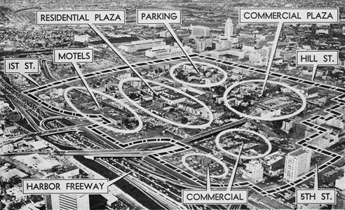
A 1960 diagram shows the Bunker Hill redevelopment plan.

Fifty years ago today, $58 million in federal funding for Los Angeles' 136-acre Bunker Hill redevelopment project was announced, paving the way for the city's redevelopment agency to begin acquiring land.

At the time, Community Redevelopment Agency head Joseph T. Bill told the L.A. Times that "within six years after the land buying begins, all the new buildings on Bunker Hill should be completed." Six, give or take 45 or so...

Senator Thomas Kuchel's October 30, 1959, announcement of the approval was in many ways a formality. The head of the Federal Housing Administration had given his ok earlier in the year.

Still, it was an important enough milestone that the headline ran across the entire front page of the Times the following day.

The $58 million was intended to create $250 million in private investment, turning Bunker Hill from a neighborhood of rundown Victorian mansions into a commercial core.

While many people wax nostalgic about the history that was lost to the wrecking crews, the project was eventually a success. The office towers that were finally built on the hilltop hold many of Downtown's jobs.

Timeline-wise, though, the project didn't exactly go as planned. Most of the towers weren't built until the 1980s, and the parcels intended to house the Grand Avenue Project still sit as parking lots awaiting development.

SHARE:

||

Related Stories:


Conversation

Guest 1

Tim on October 30, 2009, at 11:10AM – #1

What a different world. A space planned for Motels! The people of 1959 could not have imagined the world of Boutique Hotels and high end restaurants that define so many of the recent "new" downtowns, from Minneapolis to Portland to L.A.

What would the city planners and citizens of 1959 think of L.A. Live, with its high priced parking, high priced restaurants, and (compared to 1959) really high priced sporting events?


Guest 2

Eric on October 30, 2009, at 11:59AM – #2

Wish they would have set aside room to widen 110 freeway too, that would have been good. Seriously Motels? That really makes you think. Wish they would have had some mock up of what the protype end result they were looking for was.

Eric


Guest 3

Tornadoes28 on October 30, 2009, at 12:58PM – #3

It's too bad those urban planners had no clue what they were doing. Instead of having a vibrant crisscrossing of streets, they decided to make tunnels and elevated roads so it would be better for cars instead of walking and neighborhoods. For example, instead of 4th street intersecting with Fig or Flower or Grand, it is completely separate. No intersections, no corner coffee shops, no pedestrians, just for cars.


Eric Richardson () on October 30, 2009, at 01:01PM – #4

Tornadoes: Much of that was actually dictated by the state, given the freeway connections. 4th street was originally intended to be a tunnel, without even the connections at Hope or Olive.

http://blogdowntown.com/2008/11/3834-fiftyfive-years-ago-today-plans-for-4th-street


Guest 4

Eric W. on October 30, 2009, at 01:59PM – #5

Looking backwards and forwards, nobody knows what they are doing or what impact it has on the future. City planners, architects, boosters, people who have PhDs and Masters Degrees on this stuff, etc., can try and philosophize all they want about urban planning in L.A., but the fundamental problem is having too much available land to work with, and not being able to create a true downtown center in this city that is pedestrian and bike-friendly as well as works for cars. It saddens me about how difficult it is to walk around parts of Hope, Flower and Figueroa Street. Did the planners back then realize how weird the segmentation would be in the 4th, Flower, Hope and Grand area? Probably not. Does CIM, AEG, Maguire, or any of the downtown developers know what effects their developments will have now for years to come? Time will tell, and perhaps then we'll have another 50-year retrospective of "what the hell were they thinking??"


Christophe Serafino on October 30, 2009, at 02:56PM – #6

We just have to deal with and enjoy the hand we were dealt. I know things aren't perfect and a lot of things don't make sense in downtown, but I tend to look past those things or find enjoyment in those quirks.


Guest 5

JM on October 30, 2009, at 03:01PM – #7

Speaking of loving the quirks and of Bunker Hill, I saw them testing Angel's Flight last weekend. First time I've ever seen them running, which was very exciting. More on point, interesting diagram, Eric.


Thomas Stanley on October 30, 2009, at 09:14PM – #8

The "rape" of Bunker Hill.

It's sad that L.A. has lost so much of its history to "modern progress."

Too bad L.A. did not have someone like Mrs. Friedel Klussman, the San Franciscan who saved that city's cable cars...or someone like Sue Bierman, another San Franciscan who led the fight to stop the construction of a freeway through Golden Gate Park.

If L.A. had people like that, the charm of old Bunker Hill might have been saved.


Guest 6

Terry on October 30, 2009, at 11:37PM – #9

Charm? A grouping of primarily ramshackle structures on hilly terrain is charming?

When I see old photos of Bunker Hill, it looks like a mostly shabby, penniless area to me. At best, there were a few (very few) originally nice Victorians sprinkled here and there, but that was about it.

No wonder it was so easy for people in Los Angeles to head for the suburbs.


Guest 7

John C. on October 30, 2009, at 11:54PM – #10

Check that Google Map! Exactly when did the Harbor Freeway constructed circa early 1950s become "Historic U.S. (Route) 66"? What baloney. Didn't Route 66 run out to the coast via Santa Monica Blvd.???


Eric Richardson () on October 31, 2009, at 12:02AM – #11

John: Yeah, Google Maps have been getting a number of less-than-accurate additions lately as they try to produce data in-house and source it from the web.


Guest 8

Bert Green on October 31, 2009, at 01:32AM – #12

I wasn't around before Bunker Hill was cleared but people have told me it was really slummy. Without property owners willing to invest the money to upgrade the property, it usually ends up being government that steps in. And in that era the ethos was to tear it all down. I am sure it could have been stopped if the actual owners and residents had the organization and desire to stop it, but obviously it was too far gone for that.

In any case, downtown Los Angeles did have Christine Sterling, who stopped the demolition of the area surrounding the old Plaza, and saw that it was converted into the Olvera Street Historic Monument.


Guest 9

Simon Ha on October 31, 2009, at 08:11AM – #13

For those interested in redevelopment history of Bunker Hill, read Reluctant Samurai: Memoirs of an Urban Planner by Yukio Kawaratani. He was the primary planner that put in 30 years of his life to Bunker Hill Redevelopment project for LA-CRA. This will give you an idea of 'what they were thinking and how it actually happened'.


Hillsman Wright on October 31, 2009, at 10:01AM – #14

Even though we lost a big chunk of history with the demolition of the historic structures on Bunker Hill, look at the bright side. It kept those masterminds at the CRA and "civic-minded" developers busy and away from the Historic Core - which is the reason it exists intact today. Most cities bulldozed the old commercial and entertainment districts. 10 years from now, Broadway will once again be the heart of the city and the suburban urban developments, well... let's see what happens.


Guest 6

Kelly 4 on October 31, 2009, at 10:56AM – #15

Major parcels of Bunker Hill have yet to be developed, decades after the fact? Such open land would have been snapped up far more quickly if the city had never lost so much of its mainstream prosperity in the first place.

But major properties going unused for over 40 years is to be expected since the image of downtown in general has long been associated with squalor, grubby streets and abandonment or semi-abandonment until as recently as the mid-1990s. By the standards of truly vital urban areas, that description still applies today.

Caltrans data indicate that traffic on the Santa Monica Freeway on a typical day used to be heavier going in an eastern direction towards downtown. Nowadays more of the traffic in headed in the other direction.

Most businesses still avoid looking at downtown as a place to move to. They continue to prefer Burbank, Glendale, Westwood, Irvine, Woodland Hills.

Adding to the problem is that some of the major companies that once had offices in downtown either have closed down, been merged with other companies or moved to other cities.

The lesson in all this is if a community isn't attractive and wealthy enough to begin with and takes too long to be thoroughly cleaned up and upgraded, its original potential and opportunities may be lost forever. Hopefully that's not the case with Los Angeles and downtown LA in particular. But so far, a future for the city that's far better than a checkered past is definitely not guranteed.


Guest 8

Bert Green on October 31, 2009, at 02:26PM – #16

But Kelly 4, you miss one important point: The reason the traffic is so much heavier going west is that there is no effective transit to the West Side. 450,000 people work downtown, much more than on the west side, and that is in large part because of the structures that were built on Bunker Hill and Civic Center. The percentage of workers downtown that use transit or other means than a car is the highest in SoCal, and on par with downtowns like Chicago and San Francisco.

It's really only as a residential and entertainment center that downtown lags, and that is changing really fast. Downtown Los Angeles now has more residents than Lower Manhattan (Wall Street area), and its continuing to grow despite the recession, unlike other areas in Los Angeles.


Guest 10

JM on October 31, 2009, at 08:27PM – #17

John Fante's always a good read if you want an impression of what Bunker Hill was like before the redesign.


Guest 11

Jasmijn on October 31, 2009, at 09:28PM – #18

Here's what the headline was then:

As Harnisch sums up: Oct. 31, 1959: The federal government approves $58 million for urban renewal of Bunker Hill. The Times' Ray Hebert notes that the extensive project to clear "the substandard downtown area" won't cost local taxpayers a dime. By 1966, "the ultramodern commercial and industrial center envisioned on Burnker Hill will be a reality," Hebert says.


Guest 12

Tim Quinn on November 01, 2009, at 06:13AM – #19

Here are a few pics of the Hotel Melrose and Hotel Richelieu. They stood on the corner of Second and Grand on property slated for Frank Gehry's new hotel. This property still sits empty. Both hotels were standing in 1957 when the demolition began. There are many buildings of similar vintage that have been successfully restored in this city. The least you can say is that tearing them down might have been premature. Overgrown landscaping does not constitute "run down" condition.


Guest 6

Daben on November 01, 2009, at 10:56AM – #20

^ Thanks for those links! Looking at old-time images of a city always fascinates me.

This is a newer photo of the Hotel Melrose. Some of its original gingerbread design appears to have been removed towards the latter half of its existence:

http://digitallibrary.usc.edu/assetserver/controller/view/search/CHS-13062

The architect's roof-line element made a big difference in making the hotel look less plain and anonymous.

The property to the right (or south) of the Richelieu must have once been, or still was, a private residence right before it was torn down? If so, and as was the case with most of the old-time mansions on Bunker Hill, it likely had been converted to a rooming house:

http://digitallibrary.usc.edu/assetserver/controller/view/search/CHS-13065

This photo shows the daughter of the builder of the Melrose, right before it was demolished in 1957:

http://digitallibrary.usc.edu/assetserver/controller/view/search/EXM-N-~1

This is a view of Grand Avenue looking north in 1913. You can see the top of the Hotel Richelieu almost at the exact center of the photo:

http://digitallibrary.usc.edu/assetserver/controller/view/chs-m3639/CHS-5805

USC Digital mentions "utility poles line the street." I notice no effort had been made to place Bunker Hill's power lines underground, so wires and poles were inserted all over the place. That's surprising if it was supposedly a fashionable neighborhood, or at least was before the latter half of the 1900s.


Guest 13

The Dude on November 02, 2009, at 03:24AM – #21

John:

From CAHighways.org:


On September 7, 1940, Purcell (Dept. of Highways) wrote Markham (AASHTO) as follows: Pursuant to the Purpose and Policy of the American Association of State Highway Officials in the establishment of US Numbered Highways, we hereby make formal application to change the route of US 66 between Pasadena and Los Angeles, from Colorado and Figueroa Streets to the Arroyo Seco Parkway, and to designate the existing route between these points as US 66 ALTERNATE.

The proposed new route, which is expected to be opened to traffic next New Year's Day, shortens the distance by approximately 2.35 miles, and affords travel a new freeway consisting of a six lane divided highway.

As the motoring public will be better served by using this new thoroughfare, permission is requested to place US 66 ALTERNATE markers on the present routing [From Colorado Street and Broadway In Pasadena, easterly along Colorado Street to Figueroa Street thence southerly along Figueroa Street to the Arroyo Seco Parkway in Los Angeles], and to erect US 66 signs on the Arroyo Seco Parkway."


66 resumed alignment at Sunset Bl. via the Sunset Bl. ramps near Alpine St.


Thomas Stanley on November 02, 2009, at 11:02AM – #22

yes, old Bunker Hill WAS charming. I have spent a lot of time studying maps and old photos. Run-down buildings could have been lovingly restored, adapted and expanded for different uses. The original location of Angel's Flight, with buildings close up to it on both sides, was a lot more interesting than the weeds and concrete we have today. But, most importantly, the old street grid was obliterated, favoring cars over pedestrians.


Jack Skelley on November 02, 2009, at 01:44PM – #23

Imagine what could have been if just a handful of the astonishing buildings in Tim Quinn's pics had been rescued. They would have become very valuable attractions.


Jack Skelley on November 03, 2009, at 08:23AM – #24

FYI, a vigorous discussion continued on Facebook page after I commented here. http://www.facebook.com/jack.skelley?ref=profile


Add Your Voice


In an effort to prevent spam, blogdowntown commenting requires that Javascript be enabled. Please check your browser settings and try again.


blogdowntown Photo Pool

Photos of Downtown contributed by readers like you.

Downtown Blogs


Downtown Sites


Elsewhere