
City Hall's One-Time Neighbor
 Los Angeles Examiner / USC Digital Archives
[]
Los Angeles Examiner / USC Digital Archives
[]
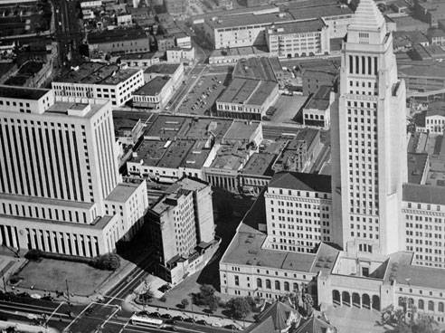
A 1947 aerial photo shows the International Bank Building, then the home of the City Health Department, next to Los Angeles' City Hall.
DOWNTOWN LOS ANGELES — While Los Angeles' City Hall today occupies an entire city block, that wasn't always the case. For nearly three decades years after the structure's 1928 opening, the International Bank Building was City Hall's northern neighbor.
Plans for the ten-story building were announced in March of 1906 by the International Savings and Exchange Bank, which had been founded in 1904. The site offered 38 feet of frontage on Spring street and 122 feet on Temple. Work got underway quickly and the structure was completed in late 1907.
The financial institution merged with Bank of Italy (which would later become Bank of America) in 1917. It continued to operate an office out of the Temple street until 1926, when the bank sold the building to the city.
Originally, the city intended to tear down the building.
It didn't do that right away, though, and instead moved the Health Department in "temporarily."
27 years later, in 1954, the department finally moved to its new home at 111 E. 1st street. Later in the year, the city contracted with Emsco Concrete Cutting to finally demolish the antiquated building, which had no fire escapes and still featured gas light fixtures in some offices.
With the building removed, the site was landscaped and finally City Hall had its block all to itself.

Walmart drew Downtown protests, but why...
Construction begins on $72 million bus...
Construction begins on $72 million bus...
Construction begins on $72 million bus...
Donated collection of maps is like 'Christmas...