blogdowntown
Not currently logged in. [Login or Create an Account]

Stay Connected


Streetcar Project Unveils New Website, Asks for Input on Route

By Eric Richardson
Published: Friday, July 10, 2009, at 12:17PM
Red Streetcar Eric Richardson []

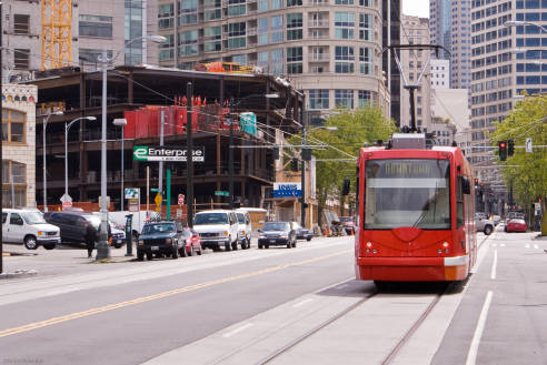
A streetcar travels through Seattle's South Lake Union district in a 2008 file photo.


For many Downtowners, 2014 just can't get here fast enough.

That's the projected opening date for a Downtown streetcar planned to link South Park, Bunker Hill and the Historic Core. L.A. Streetcar Inc. (LASI) today .

Most importantly, the site includes maps for three conceptual alignments currently under consideration.

The non-profit LASI was set up in 2008 to spearhead the streetcar project, following a model established in other cities like Portland. In January, the board named Dennis Allen its Executive Director and he's been hard at work on streetcar issues ever since.

We caught up with Dennis via email to ask a few questions about his first six months and the new routes.

BLOGDOWNTOWN: You've been on the job for just about six months now. Is your head ready to explode with all its new streetcar knowledge?

DENNIS ALLEN: Absolutely – instant streetcar guru!!! All kidding aside though, it’s been a wonderful experience so far, and I have learned quite a bit about both transportation/streetcars, as well as the federal and state funding and approval process. I am fortunate enough to have a some extremely knowledgeable partners and streetcar supporters to learn from, who really have done the lion’s share of the information gathering and technical input to date. We’re very excited as an organization to be able to present the website, the conceptual alignments, and our progress to date.

BD: The three routes that you're releasing today all serve the same basic targets (L.A. Live / Convention Center, Broadway and Bunker Hill), but do so in slightly different ways. What are some of the considerations you were looking at when putting the routes together?

DA: We've known for a while now that the initial route would serve these three key areas, which we're calling our Core Service Area. Part of the logic behind defining this Core Service Area was to transport people to/from areas they want to get to today, like the LA Live/Staples/Convention area and Bunker Hill/Civic Center, but also route them through the locations they might not have known about or seen previously, like a Broadway corridor or Pico Blvd. This is all part of the two-pronged approach that streetcar systems need to take – 1) as a local circulator and transportation solution, and 2) as one of the best economic development tools to surface in recent times.

Of course, looking at a map with the eyes of a planner, property owner, pedestrian or otherwise is obviously quite different from seeing the eventual technical issues of how and why a streetcar can run on a particular street, and in a certain way. Our next steps were to set up a series of meetings with the various different City agencies, engineering consultants, and key stakeholders to determine what technical obstacles, such as traffic, utilities, grade issues, etc., might impede us from running down various streets and areas. We also wanted to come up with a few different options that still adequately served the Core Service Area, but did so in a way that they really could be different enough to get some quality feedback from the public. As you can imagine, balancing all of these objectives was difficult, but we feel these 3 conceptual alignment options provide a good starting point to work from to reach a final alignment plan.

Now that we have these options which we as a group feel best serve the goals and objectives of these initial meetings, our board, and the overall streetcar concept, we’re excited to present them publicly and get critical feedback from the local stakeholders, because in the end, this streetcar system will need to most adequately serve those who will be riding it. So we are open and anxious to get as many opinions and comments from the public via great local community sites like yours, as well as our upcoming public meeting where we will have our team present to talk about various streetcar concepts in detail.

BD: This is a topic that has come up a lot during the planning process, but let's spend a second on the "couplet" idea that has the line running north and south on different streets. Why is that a good thing?

DA: A couplet, in which one set of tracks runs on a separate street, in a different direction, allows the benefits of the streetcar to be spread to two different streets instead of just one, and also doesn’t necessitate the additional traffic interruption on the same street. The benefit of having the lines close together, usually within a block or two, is that riders can still reach their destinations in a timely manner by walking a block over to catch the streetcar running in your direction, and not having to ride the entire route to get there.

We are also investigating the idea of having “mini-routes” on the alignment, which you can see on the maps with a dashed line connecting the couplet. The idea here is you might have a South Park loop that could run at certain times, separate and distinct from the Bunker Hill loop, and each separate and distinct from a few streetcars that run the entire route. So a rider could look up at the front of these cars that were arriving at frequent intervals, and see which route it was running, similar to the colored lines in the NY subway or the Metro system we have here in Los Angeles.


LASI, for the public to discuss the potential routes shown below. It will be held at the Bradbury Building (304 S. Broadway), in LAPD's 5th floor Hearing Room, and will run from 4:00 - 7:30pm (4:00-6:00pm: Public Viewing and Comments; 6pm: Formal Presentation; Comments from Councilmember José Huizar and Dennis Allen; 6:45-7:30pm: Public Viewing and Comments).

Click on the maps below to see them enlarged, or and click on the routes PDF.

SHARE:

||

Related Topics


Topic:
Downtown Streetcar

49 stories


Conversation

Guest 1

sarah on July 10, 2009, at 12:42PM – #1

Maybe I'm an anomaly, but I'm a little surprised as to what's being defined as the "Core Service Area" (L.A. Live / Convention Center, Broadway and Bunker Hill). Why is the financial district out of the equation? I work in the 7th and fig area and live in the old bank district/historic core, so I will probably never use this streetcar. :(


Eric Richardson () on July 10, 2009, at 12:57PM – #2

That's a good question, Sarah. Basically, this first route just can't do everything. The Financial District has been talked about for a second phase of the project. The three elements chosen for the first route were selected based on ridership generation (both from residents and visitors) and development potential.


Guest 2

ClipperLoft on July 10, 2009, at 02:23PM – #3

I am also surprised that Little Tokyo and Chinatown which is connected to Union Station is not part of the street car plans. That would give any tourists access to the entire downtown region also even if we are mainly focusing on residents.

A street car going through the civic park would seem like a no brainer.


Guest 3

Jon on July 10, 2009, at 03:46PM – #4

I vote for a modified Option 3, with Grand instead of Olive (is it possible though, to put a trolley on Upper Grand?), and heading east on 1st street until Main, and then South on Main until 4th, and then back West to Broadway.


Guest 4

Rolf on July 10, 2009, at 04:33PM – #5

I vote option 3 as well. None of them are ideal, but it is definitely better than what we have now.

I would personally like to see it come as close as possible the 7th St. Metro stop, as well as little Tokyo, thus hitting up all of the major rail stops. That would make too much sense though.

As I said, none are perfect, but its better than nuthin'...


Guest 5

John Crandell on July 10, 2009, at 08:01PM – #6

In the spirit of Angels' Flight, the individual streetcars should/must have some innate spirit part and parcel to their countenances. Therefore, I move that the rights to the names Bullwinkle, Daffy Duck, Mickey, Minnie, Pluto, Road Runner, etc. be acquired. Or how about Kate, Marlene, Clark, Spencer, Mae, Marilyn, Bette, Ginger, Gene, Montgomery, James, Jimmy, Rudolph or Charley?

After all, we're all aboard the Streetcar Named Aspiration, aren't we?

Charley would have to make a special stop on Broadway, midblock between Second and Third, right where he was first discovered, so long ago.


Guest 6

bowchikabowbow on July 10, 2009, at 10:56PM – #7

I think they should call it the party train and have it hit up all the bars and then you could have a pub crawl every weekend. That would get people into downtown and riding it. Who wouldn't like to just have some people mover take them from bar to bar while they get hammered. After the lakers game you could hop aboard the party train and just go straight to the party without having to deal with parking or driving.

But, I definitely agree that it should connect to El Pueblo, Little Tokyo, Chinatown, the Fashion District because there is no subway stops in any of those neighborhoods right now. It would also be awesome if it connected to the Dodger's stadium.


Eric Richardson () on July 11, 2009, at 10:18AM – #8

For those advocating seeing the streetcar go here and there all over Downtown, you have to remember that length equals money. Way back in September of 2005, I wrote about a meeting of the Red Car Advisory Board where we were tasked with imagining some routes.

We were given a fixed amount of string, representing the length of line that was realistic to raise funds for on this first effort. Given that length, it was amazing how the different groups coalesced on the same basic targets.


Guest 7

Russell Brown on July 11, 2009, at 03:40PM – #9

Folks should also remember that this route is phase one and not meant to connect all of downtown in every possible combinatiion. It is also not meant to replicate the route of other transit.

There will be stops on the Regional Connecter from Metro & 7th to 5th & Flower (Library & Bonaventure Hotel) and 2nd & Hope (RedCat Theatre/ Grand Ave Project phase 2) and 2nd near Broadway/ Spring or Main).

The proposed streecar routes will have connections with the Redline at the Civic center stations, Pershing Square and connections with Blue & Expo line at 11th & Flower.

Costs are about $30 million a mile.


Guest 8

JDRCRASH on July 11, 2009, at 07:30PM – #10

I like Alignment #3. It would be one big loop.


Guest 9

Downtowner on July 12, 2009, at 01:55PM – #11

I like #2 because it goes to the Convention Center. It would be the best one for tourism and growing downtown.


Guest 10

Rich Alossi on July 12, 2009, at 03:33PM – #12

I like Option 1. It's a quick and easy ride from the Historic Core to South Park, which is something we don't have now (especially in the evening). It also doesn't duplicate any major transit service while hitting a good portion of the Bunker Hill office towers.

I don't feel it's necessary to hit Little Tokyo or Chinatown in the first phase since the Downtown Connector project will do that on its own.

Also, running the streetcar down 9th Street is a much more pleasant route than, say, Olympic.

In the end, I'd prefer the South Park routing of Option 3 with the Bunker Hill connection of Option 1.


Guest 11

Dan Wentzel on July 14, 2009, at 09:06AM – #13

At first glance, I prefer Option 2, but I think any of these three routes would be a great place to start. One line cannot do everything. If this works, I hope there will be other lines.

One future possible line would be to connect downtown to the Red Line via Sunset. It could meet the Red Line at either Vermont/SantaMonica or Vermont/Sunset.

Future extensions could send the trams to Century City via the unused right-of-way in Beverly Hills or to the Sunset Strip.

But, that's probably getting ahead of ourselves.


Guest 11

Dan Wentzel on July 14, 2009, at 01:50PM – #14

Another possibility I'd like to throw out there for a future streetcar/tram is Ventura Blvd.


Guest 12

Joel on July 15, 2009, at 03:22PM – #15

Will there be some type of public-private partnership in regards to financing for the streetcar line? There was a recent article in the NYT about the creative way Ohio is financing one of it's streetcar projects in Cincinnati.


Guest 13

Hillsman Wright on July 20, 2009, at 08:48AM – #16

The streetcar will be far more effective as a couplet with a Southbound Broadway component and Northbound on Hill Street. Walking an extra block or two to Grand or Olive largely defeats the purpose of serving the Broadway corridor. People simply won't walk the extra block(s).However, whatever the route, the streetcar MUST use the middle lanes of Broadway - where the Yellow cars ran (the track is still under a foot of asphalt) and there are few, if any, utility realignments required. A curbside track on either side of Broadway seriously compromises the viability of the theatres - i.e. pick-ups and drop-offs, valet parking, teeming masses, etc.


Guest 14

Jerard on July 20, 2009, at 03:17PM – #17

I like Options 2 and 3 as a route because it connects with the Blue/Expo line station with a modification to loop to run on a couplet of Olympic and 11th.

The key question I have is where will the maintenance shop be located?

If the shop is located in a transit friendly area that could double as a focal point even include a "transit museum" of sorts. however the area in question is already gentrifying could that limit having a viable location to maintain and store the streetcars when they are not operating, so some serious thought in this area will make or break this starter project.


Add Your Voice


In an effort to prevent spam, blogdowntown commenting requires that Javascript be enabled. Please check your browser settings and try again.


blogdowntown Photo Pool

Photos of Downtown contributed by readers like you.

Downtown Blogs


Downtown Sites


Elsewhere