
Stay Connected
Census Maps
The U.S. Census Bureau released 2010 population data for California on Tuesday, March 8, 2011. Locally, Los Angeles County is now home to 9,818,605 people, while the City of Los Angeles is shown with 3,792,621 residents.
Maps use SVG, and will not work in Internet Explorer. Please use Google Chrome, Safari or Firefox.
You can read more about the creation of the maps in this blogdowntown story.

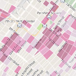
Downtown Population Change
How has the population of Downtown Los Angeles changed in the last ten years, a time when the central city has seen massive revitalization?
Uses 2010 tract data, computing 2000 population by mapping 2000 census block data to 2010 tracts.
Downtown Density
How dense is Downtown's population?
Uses 2010 census block data, showing the number of square feet per resident.
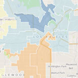
City Council Districts
How has population changed in each of Los Angeles' City Council districts? Every ten years, districts are re-aligned to "contain, as nearly as practicable, equal portions of the total population of the City."
Uses block level data for both 2000 and 2010 populations.
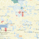
L.A. County Population Change
How has the population of Los Angeles County changed since 2000?
Uses 2010 census tract data, computing 2000 population by mapping 2000 census block data to 2010 tracts.
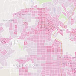
L.A. County Density
Where is L.A. County's density located?
Uses 2010 census tract data, computing 2000 population by mapping 2000 census block data to 2010 tracts.